|
|
| (не показаны 7 промежуточных версий 2 участников) |
| Строка 1: |
Строка 1: |
| | + | '''What do we know about English Holidays?''' |
| | | | |
| − | == [[The New Year Day]] ==
| |
| | | | |
| | | | |
| | | | |
| | + | === [[Stavropol]] === |
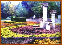
| | + | [[Изображение:Сквер у театра.jpg|thumb|left|200px|Сквер у драматического театра]] |
| | + | * [[Halloween]] |
| | + | * [[Halloween at School № 21, Stavropol]] |
| | + | * [[British Christmas]] |
| | + | * [[The New Year Day]] |
| | + | * [[Stavropol’s Coat of Arms]] |
| | | | |
| − | == Stavropol ==
| |
| | | | |
| | + | <br clear=all /> |
| | + | ===[[Мурманск|Murmansk]] === |
| | + | * '''[http://www.slideshare.net/gaart/festival-of-the-north-presentation/ Festival of Murmansk]''' |
| | | | |
| | | | |
| − | Stavropol is the main city of Stavropol Territory in the Northern Caucasus. It’s situated in the northern part of the Eastern hemisphere. Stavropol is located in the huge continent Eurasia, in the south of the Eastern-European plain. The city is at the intersection of the latitude 45 North and of the longitude 42 East.
| |
| − | Stavropol is positioned on the Caucasian Isthmus between the Black Sea and the Caspian Sea. It’s spaced almost equally from them.
| |
| − | The city has an important geopolitical meaning. The main roads to the Caucasus go through it. That’s why Stavropol is called “The Caucasus’ Gates”.
| |
| − | The borders of the city pass along the edges of Mt Stavropol’skaya in the south. The Stavropol’s lands lens out till Sengileevskoe Reservoir in the west. They include gardening joint-stock companies, reserves and city’s woods.
| |
| − | Stavropol’s total area is 244.8 sq. km. It stretches for 30.5 km from the south-west to the north-east and16.5 km from the south to the north. If you want to walk around the city, it’ll take you several days because the borders-length of it is 153 km.
| |
| − | The flat top of Mt Stavropol’skaya is bent to the north-east and goes down like steps from the South-Western district of the city to the railway station. The highest point of Stavropol is 650 metres above the sea level. It’s situated in the south-west outskirts of the city. The lowest parts of the city are located in the bottom of it in the rayon of Chapaev Street. They are 350 metres above the sea level. So the overfall of the altitudes in the city from the south-west to the north-east is more than 300 metres.
| |
| − | The central part of Stavropol is 570 metres above the sea level.
| |
| − | Limestone-shell rock is one of the main treasures of the soil. It was mined at all times. The first stone buildings were constructed from it.
| |
| − | The sands for house-building and building materials manufacture are mined in the sand-pit.
| |
| − | The gas fuel was found in Stavropol in 1910. It was used for gas heat of the brewery, restaurant, theatre, mills and bath-houses.
| |
| − | The gas fuel was also found in the basin of Sengileevskoe Reservoir.
| |
| | | | |
| | | | |
| − | [[Изображение:Сквер у театра.jpg|thumb|right|Сквер у драматического театра]]
| + | [[Категория:Иностранный язык]] |
| − | | + | [[Категория:Традиция]] |
| − | == [[Stavropol’s Coat of Arms]] ==
| + | [[Категория:Проект Хочется праздника]] |
| − | | + | [[Категория:300 ИнтеЛлектуальных школ]] |
| − | | + | |
| − | | + | |
| − | | + | |
| − | | + | |
| − | | + | |
| − | [[Категория:Иностранный язык]], | + | |
| − | [[Категория:Традиция]], | + | |
| − | [[Категория:Проект Хочется праздника]], | + | |
| − | [[Категория:300 ИнтеЛлектуальных школ]]. | + | |

